
5 Capitals worked alongside the Master Planners to assess the Phase I Ecology of a site being proposed for a new Industrial City. The site is almost 50km2 and therefore too large to survey in detail from the limited tracks across the site.
As a result 5 Capitals proposed using satellite imagery to review the main habitat features followed by ground-truthing. This process was further enhanced using 5 Capitals in-house Geographical Information System (Arc GIS 10) software to provide high quality accurate mapping of the terrain and habitats. A survey of the accessible areas of the site was undertaken to identify key species of trees, plants, birds etc. and to confirm habitat types and assign a conservation value based on biodiversity and other attributes.
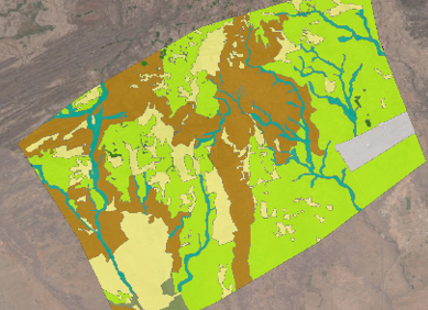
The map above identifies the key habitats over the 50km2 project site. Target notes and site photographs were also included within subsequent maps for the Phase I Habitat Report.
The information was also presented as a Conservation Map highlighting areas of high, medium and low conservation value to assist in the master planning of the city.